Showing posts with label national_park. Show all posts

Sunday, 31 March 2024

SUNDAY BEST #372 - IN OLINDA

Welcome to the meme, "My Sunday Best", which is a photographic and creative meme that allows you to showcase your talents in imaging. Every Sunday, you can post here showing an image you have created using your camera, (and/or) image processing software, and/or painting and drawing in the conventional way and have scanned in.
The rules are simple:
1) Create your image and post it up on your blog;
2) Put the "My Sunday Best" logo image link somewhere on your post so people can click and come by here;
3) Leave a comment here once you have posted;
4) Visit other posters' blogs and be amazed with their creativity.
Please do not use this meme to advertise our goods or services. This is a creative meme and any inappropriate links or comments shall be removed immediately.
The Olinda Falls Walking Track in the Dandenong Ranges National Park. An amazing place with huge eucalypt trees (the world's tallest flowering plants!) and majestic tree ferns.

You are invited to the Inlinkz link party!

Click here to enter
Last Week, Roentare in Melbourne posted this great shot of a sea cave. Please visit his blog for more beautiful photos.


Tuesday, 13 March 2018

GORGEOUS GORGE

Nitmiluk National Park is in the Northern Territory of Australia, 244 km southeast of Darwin, around a series of gorges on the Katherine River and Edith Falls. Previously named Katherine Gorge National Park, its northern edge borders Kakadu National Park. The gorges and the surrounding landscape have great ceremonial significance to the local Jawoyn people, who are custodians of Nitmiluk National Park. In Jawoyn, Nitmiluk means "place of the cicada dreaming".

Katherine Gorge, a deep gorge carved through ancient sandstone by the Katherine River, is the central attraction of the park. Katherine Gorge is made up of thirteen gorges, with rapids and falls, and follow the Katherine River, which begins in Kakadu. During the Dry Season, roughly from April to October, the Katherine Gorge waters are placid in most spots and ideal for swimming and canoeing.

There may be freshwater crocodiles in most parts of the river, as they nest along the banks, but they are harmless to humans. Saltwater crocodiles regularly enter the river during the wet season, when the water levels are very high, and are subsequently removed and returned to the lower levels at the onset of the dry season. Thus, swimming in the Wet Season is prohibited, as crocodiles don't respond to swimmers' questioning them if they are fresh or saltwater ones. Cruises of various lengths go as far as the fifth gorge.

This post is part of the Our World Tuesday meme,
and also part of the Ruby Tuesday meme,
and also part of the Travel Tuesday meme,
and also part of the Wordless Wednesday meme.


Tuesday, 23 January 2018

YELLOWSTONE

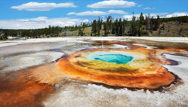
Yellowstone National Park is a national park located in the U.S. states of Wyoming, Montana, and Idaho. It was established by the U.S. Congress and signed into law by President Ulysses S. Grant on March 1, 1872. Yellowstone was the first national park in the U.S. and is also widely held to be the first national park in the world.

The park is known for its wildlife and its many geothermal features, especially Old Faithful geyser, one of its most popular features. It has many types of ecosystems, but the subalpine forest is the most abundant. It is part of the South Central Rockies forests ecoregion. Native Americans have lived in the Yellowstone region for at least 11,000 years. Aside from visits by mountain men during the early-to-mid-19th century, organised exploration did not begin until the late 1860s.

Management and control of the park originally fell under the jurisdiction of the Secretary of the Interior, the first being Columbus Delano. However, the U.S. Army was subsequently commissioned to oversee management of Yellowstone for a 30-year period between 1886 and 1916. In 1917, administration of the park was transferred to the National Park Service, which had been created the previous year. Hundreds of structures have been built and are protected for their architectural and historical significance, and researchers have examined more than a thousand archaeological sites.

Yellowstone National Park spans an area of 8,983 km2, comprising lakes, canyons, rivers and mountain ranges. Yellowstone Lake is one of the largest high-elevation lakes in North America and is centred over the Yellowstone Caldera, the largest supervolcano on the continent. The caldera is considered an active volcano. It has erupted with tremendous force several times in the last two million years. Half of the world's geothermal features are in Yellowstone, fuelled by this ongoing volcanism. Lava flows and rocks from volcanic eruptions cover most of the land area of Yellowstone. The park is the centrepiece of the Greater Yellowstone Ecosystem, the largest remaining nearly-intact ecosystem in the Earth's northern temperate zone. In 1978, Yellowstone was named a UNESCO World Heritage Site.

Hundreds of species of mammals, birds, fish, and reptiles have been documented, including several that are either endangered or threatened. The vast forests and grasslands also include unique species of plants. Yellowstone Park is the largest and most famous megafauna location in the contiguous United States. Grizzly bears, wolves, and free-ranging herds of bison and elk live in the park. The Yellowstone Park bison herd is the oldest and largest public bison herd in the United States.

Forest fires occur in the park each year; in the large forest fires of 1988, nearly one third of the park was burnt. Yellowstone has numerous recreational opportunities, including hiking, camping, boating, fishing and sightseeing. Paved roads provide close access to the major geothermal areas as well as some of the lakes and waterfalls. During the winter, visitors often access the park by way of guided tours that use either snow coaches or snowmobiles.

This post is part of the Our World Tuesday meme,
and also part of the Ruby Tuesday meme,
and also part of the Travel Tuesday meme,
and also part of the Wordless Wednesday meme.


Tuesday, 20 June 2017

ARCHES NATIONAL PARK, USA

Arches National Park is a US National Park in eastern Utah. The park is adjacent to the Colorado River, 6 km north of Moab, Utah. It is home to over 2,000 natural sandstone arches, including the world-famous Delicate Arch (shown here), in addition to a variety of unique geological resources and formations. It contains the highest density of natural arches in the world.

The park consists of 310.31 km2 of high desert located in the Colorado Plateau. Its highest elevation is 1,723 m at Elephant Butte, and its lowest elevation is 1,245 m at the visitor centre. Forty-three arches are known to have collapsed since 1977. The park receives on average 250 mm of rain a year. Administered by the National Park Service, the area was originally named a National Monument on April 12, 1929. It was redesignated as a National Park on November 12, 1971.

This post is part of the Our World Tuesday meme,
and also part of the Ruby Tuesday meme,
and also part of the Travel Tuesday meme,
and also part of the Wordless Wednesday meme.

Saturday, 24 May 2014

GLEN HELEN GORGE, NT

Glen Helen Gorge in Australia's Northern Territory is a great place to view the West MacDonnell Ranges. The gorge is located 132 kilometres from Alice Springs, in the western reaches of the West MacDonnell Ranges, and is a popular overnight stop for drivers embarking on the Red Centre Way from Alice Springs. The landscape around Glen Helen is spectacular - a towering sandstone wall is the first thing you see as you arrive.
The area includes views of Mount Sonder, one of the highest points in Central Australia, which changes colours with the light. At Glen Helen Gorge the ranges part to make way for the Finke River. The permanent Finke River waterhole is an important refuge in the hot summer months, for all nine species of fish recorded for the Finke, and migrating waterbirds. From here the Finke River continues and makes its way to the Simpson Desert.

The area's traditional owners believe that this inviting swimming spot is the home of an ancient and powerful Rainbow Serpent, and regard it as off limits. The medium grade one-day Section 10 of the 223-kilometre Larapinta Trail walk ends at Glenn Helen Junction.

This post is part of the Weekend Reflections meme,
and also part of the Weekly TopShot meme,
and also part of the Scenic Weekends meme.


Sunday, 28 July 2013

WALLABY

A wallaby is any of about thirty species of Macropodidae family. It is an informal designation generally used for any macropod that is smaller than a kangaroo or wallaroo that has not been designated otherwise.

Forest-dwelling wallabies are known as "pademelons" (genus Thylogale) and "dorcopsises" (genera Dorcopsis and Dorcopsulus). The name "wallaby" comes from the Eora, who were the first human inhabitants of the Sydney area. Young wallabies are known as "joeys", like many other marsupials. Adult male wallabies are referred to as "bucks", "boomers", or "jacks". An adult female wallaby is known as a "doe", "flyer", or "jill". A group of wallabies is called a "court", "mob", or "troupe".

Although members of most wallaby species are small, some can grow up to six feet in length (from head to tail).Wallabies are herbivores whose diet consists of a wide range of grasses, vegetables, leaves, and other foliage. Due to recent urbanisation, many wallabies now feed in rural and urban areas. Wallabies cover vast distances for food and water, which is often scarce in their environment. Mobs of wallabies often congregate around the same water hole during the dry season.

Their powerful hind legs are not only used for bounding at high speeds and jumping great heights, but also to administer vigorous kicks to fend off potential predators. Wallabies also have a powerful tail that is used mostly for balance and support.The tails are also known to knock even the strongest of predators with one tail whip.

Wallabies face several threats. Wild dogs, foxes, and feral cats are among the predators they face. Humans also pose a significant threat to wallabies due to increased interaction. Many wallabies have been involved in vehicular accidents as they often feed near roads and urban areas.

This post is part of the Camera Critters meme.

Monday, 29 April 2013

ALONNISOS

Alonnisos is a Greek island in the Aegean Sea. After Skiathos and Skopelos it is the third member of the Northern Sporades. It is 3 km E of the island of Skopelos. Alonnisos is also the name of a village on the island, as well as the municipality that encompasses the island and the village.The village of Alonnisos is located on the southern part of the island. It is locally known as Chora. The main port of the island is located in the southeast and is called Patitiri. There is ferry and hydrofoil service from Patitiri to Volos, Agios Konstantinos, and Thessaloniki on the mainland and to the islands of Skiathos, Skopelos and Skyros. The bay at the southern end of the island is also called Alonnisos.

The National Marine Park of Alonnisos was founded by Presidential Decree on 28 May 1992 and is the first to be founded in Greece. It is located in Eastern Central Greece, in the region of the North Sporades Islands. The Sporades administratively belong to the district of Skopelos in the Prefecture of Magnesia. Alonnisos is the only inhabited island in the Marine National Park.

This post is part of the Blue Monday meme,
and also part of the Nature Footsteps Inspiring Photography meme.

Saturday, 16 February 2013

TE ANAU TO MILFORD SOUND HWY

Climbing through the Southern Alps, State Highway 94 is one of the highest and most scenic state highways in New Zealand. The highest part of the road is at 940 metres above sea level. The Milford Road, part of SH94, takes you from Te Anau through Fiordland National Park to the major tourist gateway - Milford Sound.

Over one million people visit Fiordland every year and Milford Sound is one of their favourite destinations. A part of UNESCO World Heritage Site, it is no wonder that Milford Sound was described by Rudyard Kipling as the 'eighth wonder of the world'.One of the most incredible and frequently overlooked features of Milford Sound is the journey to get there.

Transit New Zealand looks after the Milford Road which provides the only road access to Milford Sound. It is therefore essential for Transit to keep this road safe and open all year round. In winter season (May to September) snow, ice and risk of avalanches make safe driving critical.

We visited this part of New Zealand in February 2003, in the middle of the Southern Summer. As you can see form the photos, there was still snow on the mountain peaks and Milford Sound was shrouded in clouds. It was all very beautiful nevertheless!

This post is part of the Weekend Reflections meme,
and also part of the Weekly TopShot meme.


Wednesday, 9 May 2012

LITCHFIELD NATIONAL PARK, NT, AUSTRALIA

Litchfield National Park, covering approximately 1500 km2, is near the township of Batchelor, 100 km south-west of Darwin, in the Northern Territory of Australia. Each year the park attracts over 260,000 visitors. Proclaimed a national park in 1986, it is named after Frederick Henry Litchfield, a Territory pioneer, who explored areas of the Northern Territory from Escape Cliffs on the Timor Sea to the Daly River in 1864.

Florence Falls is a double-plunge waterfall leading to a popular swimming hole. A short distance away is the Buley Rockhole, where visitors will find a long series of cascading plunge pools, perfect for bathing in. A number of other spectacular falls can also be visited, including Wangi Falls, Tolmer Falls and Tjaetaba Falls.

Litchfield National Park offers a wide range of walking tracks, but it is strongly recommended that overnight walks are registered with the Overnight Walker Registration Scheme. Walkers must camp in designated campgrounds and do their utmost not to damage the flora and fauna of the Park.

Magnetic Termite Mounds are built by termites and are amazing architectural feats complete with arches, tunnels, chimneys, insulation and nursery chambers. The mounds are aligned north to south to minimise the exposure to the heat of the sun. You will experience seeing numerous Termite mounds are found all over  the Northern Territory, but Litchfield National Park and especially the formal viewing boardwalk and platform is a perfect place to see these imposing structures.

This post is part of Kim's Water World Wednesday meme,
and also part of Susan's Outdoor Wednesday meme,
and also part of Nature Footsteps Waters meme.