Wednesday, 29 February 2012

KAKADU NATIONAL PARK, AUSTRALIA

Kakadu National Park is in the Northern Territory of Australia, 171 km southeast of Darwin. Kakadu National Park is located within the Alligator Rivers Region and covers an area of 19,804 square km (7,646 square miles), extending nearly 200 kilometres from north to south and over 100 kilometres from east to west. It is the size of Slovenia, about one-third the size of Tasmania, or nearly half the size of Switzerland. The Ranger Uranium Mine, one of the most productive Uranium mines in the world, is contained within the park.
The name Kakadu comes from the mispronunciation of Gaagudju, which is the name of an Aboriginal language formerly spoken in the northern part of the Park. Kakadu is ecologically and biologically diverse. The main natural features protected within the National Park include: Four major rivers, six diverse geographical landforms and a huge variety of native flora and fauna.

Aboriginal people have occupied the Kakadu area continuously for at least 40 000 years. Kakadu National Park is renowned for the richness of its Aboriginal cultural sites. There are more than 5000 recorded art sites illustrating Aboriginal culture over thousands of years. The archaeological sites demonstrate Aboriginal occupation for at least 20 000 and possibly up to 40 000 years.   The cultural and natural values of Kakadu National Park were recognised internationally when the Park was placed on the UNESCO World Heritage List. This is an international register of properties that are recognised as having outstanding cultural or natural values of international significance.

Approximately half of the land in Kakadu is aboriginal land under the Aboriginal Land Rights (Northern Territory) Act 1976 and most of the remaining land is currently under claim by Aboriginal people. The areas of the Park that are owned by Aboriginal people are leased by the traditional owners to the Director of National Parks to be managed as a national park. The remaining area is Commonwealth land vested under the Director of National Parks. All of Kakadu is declared a national park under the Environment Protection and Biodiversity Conservation Act 1999.


This post is part of the Watery Wednesday meme,
and also the Outdoor Wednesday meme.


During the wet season (Gudjewg - November-April),  floodplains are full, waterfalls are flowing, native vegetation is vibrant, and dramatic storms and sunsets are common

Nymphaea violacea - native blue water lily

Nourlangie Rock - A significant aboriginal cultural site with many rock paintings
The "X-ray" tradition in Aboriginal art is thought to have developed around 2000 B.C. and continues to the present day. As its name implies, the X-ray style depicts animals or human figures in which the internal organs and bone structures are clearly visible. X-ray art includes sacred images of ancestral supernatural beings as well as secular works depicting fish and animals that were important food sources
Ubirr, another significant site with many rock paintings 
A barramundi (local fish) rock painting


Tuesday, 28 February 2012

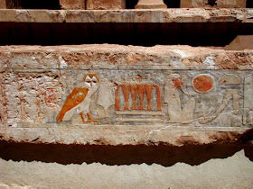
EGYPT - MORTUARY TEMPLE OF HATSHEPSUT

The Mortuary Temple of Queen Hatshepsut, the Djeser-Djeseru ("Holy of Holies"), is located beneath the cliffs at Deir el Bahari on the west bank of the Nile near the Valley of the Kings in Egypt. The mortuary temple is dedicated to the sun god Amon-Ra and is located next to the mortuary temple of Mentuhotep II, which served both as an inspiration, and later, a quarry. It is considered one of the "incomparable monuments of ancient Egypt." Hatshepsut's chancellor, royal architect, and possible lover Senemut oversaw construction and most likely designed the temple. Senemut who was Hatshepsut's chancellor, royal architect, and possible lover oversaw construction and most likely designed the temple.

Although the adjacent, earlier mortuary temple of Mentuhotep was used as a model, the two structures are different in many ways. Hatshepsut's temple has a lengthy, colonnaded terrace that deviates from the centralised structure of Mentuhotep’s model – an anomaly that may be caused by the decentralised location of her burial chamber. There are three layered terraces reaching 97 feet tall. Each 'storey' is articulated by a double colonnade of square piers, with the exception of the northwest corner of the central terrace, which employs Proto Doric columns to house the chapel. These terraces are connected by long ramps which were once surrounded by gardens with foreign plants including frankincense and myrrh trees. The layering of Hatshepsut’s temple corresponds with the classical Theban form, employing pylons, courts, hypostyle hall, sun court, chapel and sanctuary.

The relief sculpture within Hatshepsut’s temple recites the tale of the divine birth of a female pharaoh – the first of its kind. The text and pictorial cycle also tell of an expedition to the Land of Punt, an exotic country on the Red Sea coast. While the statues and ornamentation have since been stolen or destroyed, the temple once was home to two statues of Osiris, a sphinx avenue as well as many sculptures of the Queen in different attitudes – standing, sitting, or kneeling. Many of these portraits were destroyed at the order of her resentful stepson Thutmose III after Hatshepsut's death.

Hatshepsut’s temple is considered the closest Egypt came to Classical architecture. Representative of New Kingdom funerary architecture, it both aggrandises the pharaoh and includes sanctuaries to honour the gods relevant to her afterlife. This marks a turning point in the architecture of Ancient Egypt, which forsook the megalithic geometry of the Old Kingdom for a temple which allowed for active worship, requiring the presence of participants to create the majesty. The linear axiality of Hatshepsut’s temple is mirrored in the later New Kingdom temples.

The day we visited the temple was avery hot one with the temperature over 40˚C. It was an effort to walk around in the bright sun and heat, but the sight was worth every drop of perspiration and every risk of heatstroke!

This post os part of Julie's Taphophile Tragics meme,
and also for the Our World Tuesday meme.


Monday, 27 February 2012

LITTLE INDIA - SINGAPORE

Little India is an ethnic neighbourhood found in Singapore that has Tamil cultural elements and aspects of other cultures. Little India lies to east of the Singapore River—across from Chinatown, located west of the river—and north of Kampong Glam. Both areas are part of the urban planning area of Rochor. Little India is more commonly known as Tekka in the local Tamil community.


Little India is distinct from the Chulia Kampong area, which, under the Raffles Plan of Singapore, was originally a division of colonial Singapore where Tamil immigrants would reside under the British policy of ethnic segregation. However, as Chulia Kampong became more crowded and competition for land escalated, many ethnic Tamils moved into what is now known as Little India. (The Chulia Kampong district no longer exists as a distinct area).


The Little India area is reported to have developed around a former settlement for Tamil convicts. Its location along the Serangoon River originally made it attractive for raising cattle, and trade in livestock was once prominent in the area. Eventually, other economic activity developed, and by the turn of the 20th century, the area began to look like a Tamil ethnic neighbourhood.


We love visiting Little India every time we are Singapore. It is a vibrant, colourful, busy and colourful place. Some great shopping to be had there also.


This post is part of the Monday Mellow Yellow meme.


RONCHAMP CHAPEL - FRANCE

Ronchamp is a commune in the Haute-Saône department in the region of Franche-Comté in eastern France. It is located between the Vosges and the Jura mountains. The famous church close to the town is informally known as "Ronchamp", but formally it is the chapel of Notre Dame du Haut (Chapelle Notre-Dame-du-Haut de Ronchamp). It was completed in 1954 and is one of the finest examples of the architecture of Franco-Swiss architect Le Corbusier, and one of the most important examples of twentieth-century religious architecture.


Notre Dame du Haut was thought of as a more extreme design of Le Corbusier’s late style. The chapel is a simple design with two entrances, a main altar, and three chapels beneath towers. Although the building is small, it is powerful and complex. The chapel is the latest of chapels at the site. The previous chapel was completely destroyed there during World War II. The previous building was a 4th century Christian chapel. But, at the time the new building was being constructed, Corbusier wasn’t exactly interested in “Machine Age” architecture. He felt his style was more primitive and sculptural, so he decided to build something more interesting.


Here is André Campra's (1660-1744) - "De profundis" (Psalm 130). It is a lament, a Penitential Psalm, used in liturgical prayers for the faithful departed in Western liturgical tradition. In deep sorrow the psalmist cries to God (1-2), asking for mercy (3-4). The psalmist's trust (5-6) becomes a model for the people (7-8).

This post is part of the Sunday Psalms meme.


Saturday, 25 February 2012

STRASBOURG, FRANCE

Strasbourg is the capital and principal city of the Alsace region in eastern France and is the official seat of the European Parliament. Located close to the border with Germany, it is the capital of the Bas-Rhin département. The city and the region of Alsace are historically German-speaking, explaining the city's Germanic name. In 2006, the city proper had 272,975 inhabitants and its urban community 467,375 inhabitants. With 638,670 inhabitants in 2006, Strasbourg's metropolitan area (aire urbaine) (only the part of the metropolitan area on French territory) is the ninth largest in France.

Strasbourg is the seat of several European institutions, such as the Council of Europe (with its European Court of Human Rights, its European Directorate for the Quality of Medicines and its European Audiovisual Observatory) and the Eurocorps, as well as the European Parliament and the European Ombudsman of the European Union. The city is the seat of the Central Commission for Navigation on the Rhine.

Strasbourg's historic city centre, the Grande Île (Great Island), was classified a World Heritage site by UNESCO in 1988, the first time such an honour was placed on an entire city centre. Strasbourg is fused into the Franco-German culture and although violently disputed throughout history, has been a bridge of unity between France and Germany for centuries, especially through the University of Strasbourg, currently the largest in France, and the coexistence of Catholic and Protestant culture.

I am really stretching the resolution of these images, which were taken in 1999 with one of the first digital cameras I owned.

This post is part of the Weekend Reflections meme.


Friday, 24 February 2012

MONDAY MORNING

You'd better enjoy the weekend because Monday is not too far away...


This post is part of the 'Challenge Walk In The Street' meme


Thursday, 23 February 2012

TAJ MAHAL, INDIA


The Taj Mahal is a white Marble mausoleum located in Agra, India. It was built by Mughal emperor Shah Jahan in memory of his third wife, Mumtaz Mahal. The Taj Mahal is widely recognised as the jewel of Muslim art in India and one of the universally admired masterpieces of the world's heritage. The Taj Mahal is the finest example of Mughal architecture, a style that combines elements from Persian, Turkish and Indian architectural styles.

In 1983, the Taj Mahal became a UNESCO World Heritage Site. While the white domed marble mausoleum is the most familiar component of the Taj Mahal, it is actually an integrated complex of structures. The construction began around 1632 and was completed around 1653, employing thousands of artisans and craftsmen. The construction of the Taj Mahal was entrusted to a board of architects under imperial supervision, including Abd ul-Karim Ma'mur Khan, Makramat Khan, and Ustad Ahmad Lahauri. Lahaur is generally considered to be the principal designer.

Visiting the Taj Mahal was one of the most memorable experiences we had in India. We viewed it at three times of the day: Dawn, noon and evening and the changing light presented it to us in different moods but always exquisitely beautiful!

This post is part of the Skywatch Friday meme.


YOU REALLY KNOW YOU'RE IN AUSTRALIA...

When you see signs like these!

This post is part of the Signs Signs meme.


This is on the road to Broken Hill.